Our world may seem fragile, but Earth has been around for a very long time. If we ventured far back into the past, would we reach a time when it looked fundamentally different?
The answer lies in some of the earliest extensive relics of Earth’s surface, found in a remote corner of southern Africa’s highveld – a region known to geologists as the Barberton Greenstone Belt.
The geological formations in this region have proved difficult to decipher, despite many attempts. But our new research has shown the key to cracking this code lies in geologically young rocks laid down on the seafloor of the Pacific Ocean off the coast of New Zealand.
This has opened up a new perspective on what our planet looked like when it was still young.
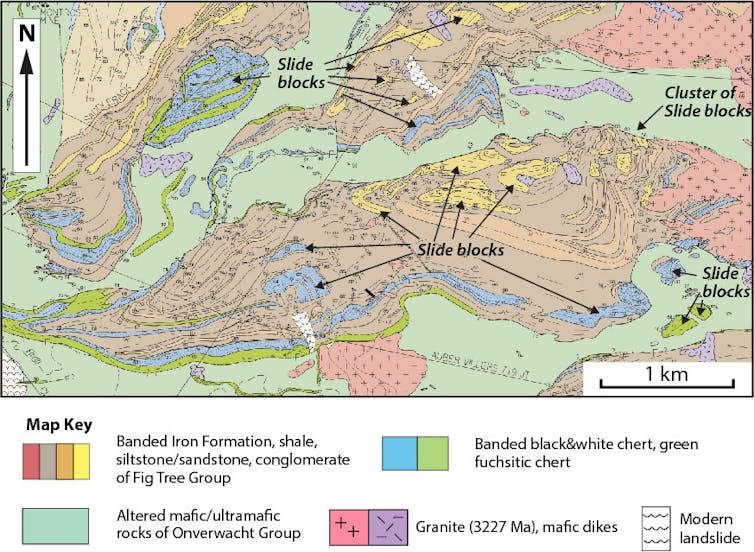
Our work began with a new, detailed geological map (by Cornel de Ronde) of part of the Barberton Greenstone Belt. This has revealed a fragment of the ancient deep seafloor, created some 3.3 billion years ago.
There was, however, something very strange about this seafloor, and it has taken our study of rocks laid down in New Zealand, at the other end of the Earth’s long history, to make sense of it.
Read more:
Earth’s early evolution: fresh insights from rocks formed 3.5 billion years ago
We argue that the widely held view of the early Earth as a hotter place, free of earthquakes and with a surface so weak it was unable to form rigid plates is wrong.
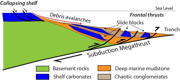
Instead, the young Earth was continually rocked by large earthquakes, triggered as one tectonic plate slid beneath another in a subduction zone as part of plate tectonics – just like New Zealand today.
Shutterstock/Instinctively RDH
Jumbled rocks
Geologists have long found it hard to interpret the ancient rocks of the Barberton Greenstone Belt.
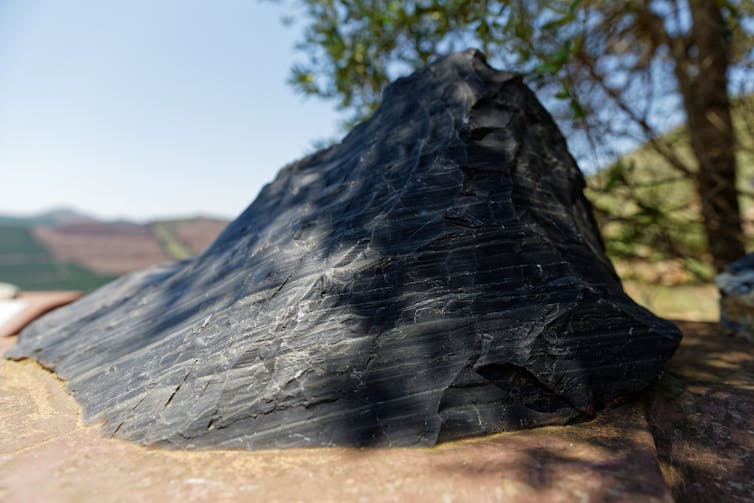
Layers that formed on land or in shallow water – for example, beautiful crystals of barite that had crystallised as evaporites, or the remains of bubbling mud pools – are found sitting on top of rocks that accumulated on the deep seafloor. Blocks of volcanic rock, chert, sandstone and conglomerate lie topsy turvy and jumbled up.

Shutterstock/Beate Wolter
We realised this map looked remarkably similar to a geological map (by Simon Lamb) made of the aftermath of much more recent submarine landslides. These were triggered by great earthquakes along New Zealand’s largest fault, the megathrust in the Hikurangi subduction zone.
The bedrock is made of a jumble of sedimentary rocks, originally laid down on the seafloor off the coast of New Zealand some 20 million years ago. This region lay on the edges of the deep oceanic trench, where the Pacific tectonic plate is sliding down in a subduction zone triggering frequent large earthquakes.

Simon Lamb, CC BY-SA
The rocks in New Zealand are the key to reading the geological record in the Barberton Greenstone Belt.
What was once thought to be untranslatable turns out to be a remnant of a gigantic landslide containing sediments deposited both on land or in very shallow water, jumbled with those that accumulated on the deep seafloor.

Cornel de Ronde, CC BY-SA
The importance of this lies in the fact that New Zealand’s geological record is uniquely created by the profound effects of large earthquakes in a subduction zone. This is still happening today, most recently in November 2016, when the magnitude 7.8 Kaikoura earthquake set off vast submarine landslides and debris avalanches that flowed down into deep water.
We found the oldest record of these earthquakes, hidden in the highveld of southern Africa.
The key to other mysteries
Our work may have unlocked other mysteries, too, because subduction zones are also associated with explosive volcanic eruptions.
In January 2022, Tonga’s Hunga Tonga-Hunga Ha’apai volcano erupted with the energy of a 60 Megaton atomic bomb, sending a vast cloud of ash into space. Over the next 11 hours, more than 200,000 lightning strikes flashed through this cloud.
In the same volcanic region, underwater volcanoes are erupting an extremely rare type of lava called boninite. This is the closest modern example of a lava that was common in the early Earth.
Read more:
Origin of life: lightning strikes may have provided missing ingredient for Earth’s first organisms
The vast amounts of volcanic ash found in the Barberton Greenstone Belt may be an ancient record of similar volcanic violence. Perhaps the associated lightning strikes created the crucible for life where the basic organic molecules were forged.
Hidden deep in the south-west Pacific are echoes of our planet not long after it was created. They provide unexpected clues about the origins of the world we know today, and possibly life itself. The key to this turns out to be the subduction of tectonic plates.


