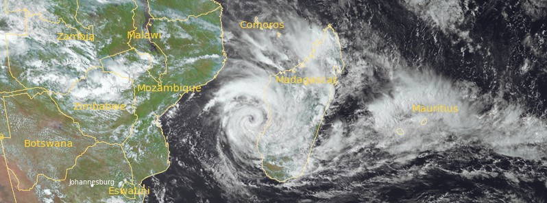
Tropical Cyclone “Cheneso” rapidly intensified after spending 5 days over Madagascar, bringing death and destruction. The system is expected to further intensify as it moves near the SW coast of the country over the next few days, bringing more heavy rainfall. Parts of northern Madagascar have already received more than 1 000 mm (40 inches) of rain.
Cheneso formed around 12:00 UTC on January 18, 2023, as the fourth named storm of the 2022/23 Southwest Indian Ocean cyclone season and made landfall around 07:45 UTC (10:45 LT) on January 19, north of the city of Antalaha in northern Madagascar with maximum sustained winds of 90 km/h (55 mph) and gusts up to 120 km/h (75 mph). This is the first tropical cyclone of the season to make landfall in Madagascar.
The cyclone dropped heavy rains as it slowly moved over the country and exited into the Mozambique Channel, off the southwest coast of Madagascar on January 24. It then rapidly intensified, quickly surpassing its landfall intensity.
According to the National Bureau of Risk and Disaster Management (BNGRC), 7 people have died and 13 others are missing, as of January 25. Approximately 14 400 individuals have been temporarily displaced to 55 accommodation sites, while up to 35 000 people have been affected.
Widespread damage has been reported to nearly 10 570 houses, and about 100 classrooms, disrupting access to education for a number of students.
Several northern and central Madagascar communities have been isolated, as roads have been damaged by floods or landslides.
At 01:00 UTC on January 25, the center of Tropical Cyclone “Cheneso” was located on the Mozambique Channel, about 135 km (84 miles) west of coastal Morondava City in Menabe Region, central-western Madagascar.
At 15:00 UTC, its maximum sustained winds were 130 km/h (80 mph), with gusts to 160 km/h (100 mph).
Over the next three days, Cheneso is expected to continue intensifying, while moving south over the Mozambique Channel, not far from the Malagasy coast.
The storm is expected to peak as a major cyclone with maximum sustained winds of over 185 km/h (115 mph) on January 27 as it gradually curves southeastwards.
Rainfall still remains an enormous threat with this storm, with another 500 mm (20 inches) possible in some areas, and 250 mm (10 inches) further north, where it’s believed that over 1 000 mm (40 inches) have already fallen.
1 Madagascar – Tropical Cyclone CHENESO Update – DG ECHO – January 25, 2023
2 Cyclone Cheneso intensifying off the coast of Madagascar – Force Thirteen – January 25, 2023

