


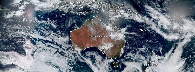
The Australian Bureau of Meteorology (BOM) is warning residents of continued showers and thunderstorms across northern Australia and heatwave conditions in western and southern regions. Major flooding continues along parts of the Fitzroy River in Western Australia and minor to moderate flood warnings are in place in Queensland, the Northern Territory and Western Australia.
Showers and thunderstorms continue across northern Australia, with heatwave conditions continuing for much of western and southern Australia over the next few days and into the weekend. Rain and thunderstorms in the Northern Territory and Queensland are becoming widespread as remnant moisture from ex-Tropical Cyclone “Ellie” combines with surface troughs to produce moderate to heavy rainfalls.1
Major Flooding is currently ongoing along parts of the Fitzroy River in Western Australia, with significant community impacts ongoing upstream, including at Fitzroy Crossing. In addition, Minor to Moderate Flood Warnings are also current in Queensland, the Northern Territory and Western Australia, in addition to a Flood Watch through western Queensland.
Lingering tropical moisture will continue to generate showers and thunderstorms over large areas of northern Australia in the coming days. The focus of rainfall will be in northern and central Queensland, but showers and storms will also be a feature for the Northern Territory and Kimberley. Heavy localized falls may produce flash and riverine flooding.

While northern Australia is experiencing wet and stormy conditions, much of southern Australia, from Western Australia to Tasmania, is experiencing very hot and dry weather this week, with the heat set to peak on the weekend in the southeast of the country.
In southwest Western Australia, dry lightning sparked a number of bushfires in recent days. Fires on the landscape, combined with high temperatures and gusty winds have created dangerous conditions in some areas.

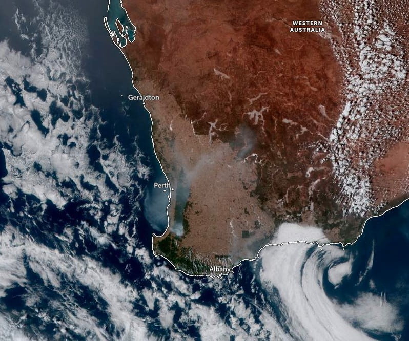
The Fire Danger Rating remains High in Western Australia and will increase to Extreme over the weekend. High to Extreme fire dangers are also forecast for parts of South Australia, Victoria, Tasmania and inland New South Wales as temperatures rise.

Maximum temperatures are forecast to be 8 to 16 °C (14 – 39 °F) above average by Saturday, January 14, reaching the low-to-mid 30s (°C) in Tasmania, and the high-30s (°C) to low 40s (°C) in Victoria, South Australia and inland New South Wales. Low-to-severe intensity heatwave conditions will develop, with high overnight minimums providing little relief from the daytime heat.
The BOM advises communities to stay informed by monitoring the latest forecast and warnings on their website and weather app and to follow the advice of emergency services.
1 National Weather Update: rain and storms in northern Australia, heat and fire danger in the west and south – BOM – January 11, 2023 at 05:00 UTC (16:00 AEST)


