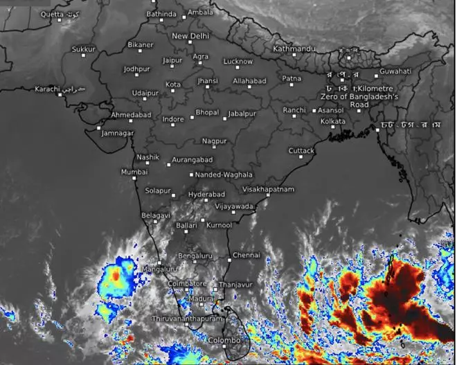
True to predictions of India Meteorological Department (IMD), a fresh low-pressure area has formed over the South Andaman Sea and neighbourhood on Monday morning, which the national forecaster expects to steadily intensify as a cyclone by Thursday as it nears the North Tamil Nadu-Puducherry-South Andhra Pradesh coasts. The IMD has not indicated the likely landfall area just yet.
Detailing the path of the projected intensification, the IMD said the ‘low’ is likely to concentrate into a depression over the South-East Bay of Bengal, slightly to the West-North-West of its current location, by Tuesday evening. It would continue to move in the same direction and intensify into a deep depression and ultimately into a cyclone on Thursday morning.

Dangerous thunderstorms (in red) around the periphery of the low-pressure area on Monday morning, as revealed by satellite pictures. This is forecast to develop into a cyclone over the next two-three days.
Depression by Tuesday evening
By this time, it would have reached the Southwest Bay of Bengal near the North Tamil Nadu-Puducherry and adjoining South Andhra Pradesh coasts. Compared to the warmer sea-surface temperatures over the high seas, the coastal waters are slightly cool on Monday. It may not be enough to stop the cyclone on its path, but could likely prevent its further intensification. Also, wind shear values near the coast are high currently, and global models indicate these values may rise even more going forward. Wind shear refers to the change in speed and direction of opposing winds at higher levels of the atmosphere. High wind shear values could ‘behead’ the storm tower and compromise it structure as it nears for a landfall, and ‘defang it’ to some extent.
Will break week-long lull
Development of a cyclone comes more than a week after a well-marked low-pressure area (an intensified form of a conventional ‘low’) stalled near the coast, failed to live up to its promise, and rained it down over a chosen few areas after crossing the coast on the sly. A lull had descended over the South Peninsula ever since, denying it what could have been a peak phase of North-East monsoon. Slow-moving systems such as ‘low’s or well-narked ‘lows’ benefit the land most given their longer tenure that translates into better amounts of realised rainfall. In comparison, a cyclone moves rapidly over land with high winds and heavy to very heavy rainfall over a short period of time, triggering quick run-off and collateral damage to lives and property on its trail.
Heavy rain forecast
The IMD has forecast widespread light to moderate rainfall with isolated heavy falls over the territorial gateway of the Andaman and Nicobar Islands over Monday and Tuesday. Movement of the low-pressure system moves towards the South-West Bay will unfold enhanced rainfall North Coastal Tamil Nadu, Puducherry, Karaikal and South-Coastal Andhra Pradesh from the midnight of Wednesday. It will escalate to rainfall at most places with isolated heavy to very heavy rainfall over North Tamil Nadu (including Chennai) and Puducherry and isolated heavy over the South Andhra Pradesh on Thursday. Squally weather (wind speeds 40-45 kmph gusting to 55 kmph) may very unfold over the Andaman and Nicobar Islands and the Andaman Sea on Monday.
Squally weather likely
Squally winds (50-60 kmph gusting to 70 kmph, near-cyclonic) may prevail over the South-West Bay and adjoining Sri Lanka coast on Wednesday; may reach 60-70 kmph gusting to 80 kmph over the same region on Thursday, before winding down to 45-55 kmph gusting to 65 kmph on Friday .Winds with speed reaching 50-60 kmph gusting to 70 kmph may commence along and off the Tamil Nadu, Puducherry, South Andhra Pradesh coasts and the Gulf of Mannar from Thursday morning. They will ramp up to to 60-70 kmph gusting to 80 kmph from the evening, coinciding with a likely cyclone landfall, and reduce to 45-55 kmph gusting to 65 kmph on Friday.


