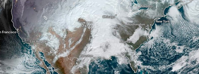
Severe thunderstorms spawned destructive tornadoes in the southern United States on December 13, 2022, leaving at least one person dead and several people missing. Severe storms with all hazards, including intense tornadoes, and heavy to excessive rain that could cause flash flooding are forecast to continue across the Deep and Middle South on December 14.
A child is dead, his mother is missing, another person is hurt and multiple homes are destroyed in the wake of tornadic storms that blew through the Four Forks area, Caddo Parish, Louisiana on December 13.1
“It’s really a sad, sad situation. And it’s one of the most unusual things I have ever seen,” Caddo Sheriff Steve Prator said, noting that the child’s body was found about 800 m (0.5 miles) from where the house used to be.
Caddo Sheriff’s Office reports that several structures were damaged and electrical lines and trees were knocked down in the area. The few houses that were in one area were destroyed, the sheriff said.
Early on, authorities reported that one woman was taken to a hospital for treatment of unknown injuries, and two people were missing.
“It’s a horrible mess down there … we’re following debris fields trying to find the actual residence, then trying to find if there’s people inside the residence,” Caddo Parish Sheriff Stephen Prator told AccuWeather National Reporter Bill Wadell about the situation in Four Forks.2
The National Weather Service Fort Worth office confirmed 5 tornadoes in North Texas — 1 in Wise County, 1 west of Paris, Texas, and 3 in Tarrant County, where 5 people were injured.
According to the Grapevine Police Department, none of the injuries sustained are life-threatening.
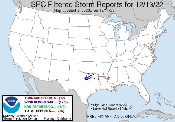
The NWS Storm Prediction Center is reporting 12 tornadoes on December 13 – 5 in Louisiana, 4 in Texas, and 3 in Mississippi.
This severe weather outbreak is expected to continue on December 14 and into Thursday, December 15.

There is an Enhanced Risk of severe thunderstorms and a Slight to Moderate Risk of excessive rainfall over the Lower Mississippi Valley/Central Gulf Coast through Thursday, December 15, NWS forecaster Ziegenfelder noted.3
The Storm Prediction Center (SPC) has issued an Enhanced Risk of severe thunderstorms over the Lower Mississippi Valley through Wednesday morning. The hazards associated with these thunderstorms are frequent lightning, severe thunderstorm wind gusts, hail, and a few tornadoes.
In addition, there is an increased risk of EF2 – EF5 tornados over parts of the region.
Moreover, the heavy rain associated with the thunderstorms will produce excessive rainfall over parts of the Lower Mississippi Valley. Therefore, the Weather Prediction Center (WPC) has issued a Slight Risk of excessive rainfall for parts of the Lower Mississippi and Tennessee Valleys through Wednesday morning.
The associated heavy rain will create mainly localized areas of flash flooding, with urban areas, roads, and small streams the most vulnerable.
The threat of severe thunderstorms and excessive rainfall continues on Wednesday as the front moves eastward. Therefore, the SPC has issued an Enhanced Risk of severe thunderstorms over the Lower Mississippi Valley/Central Gulf Coast for Wednesday into Thursday morning.
The hazards associated with these thunderstorms are frequent lightning, severe thunderstorm wind gusts, hail, and a few tornadoes. In addition, there is an increased risk of EF2 – EF5 tornados over parts of the region.
The threat of excessive rainfall increased on Wednesday with the heavy rain. Therefore, the WPC has issued a Moderate Risk of excessive rainfall with these thunderstorms over parts of Lower Mississippi Valley, Central Gulf Coast, and the Southeast for Wednesday into Thursday morning.
The associated heavy rain will create numerous areas of flash flooding. Furthermore, many streams may flood, potentially affecting larger rivers.
The threat of severe thunderstorms and excessive rainfall will decrease on Thursday. Therefore, the SPC has issued a Slight Risk of severe thunderstorms over parts of the Southeast on Thursday.
The hazards associated with these thunderstorms are frequent lightning, severe thunderstorm wind gusts, hail, and a few tornadoes.
“The excessive rainfall threat ends on Thursday for now. Still, heavy rain may occur over parts of the Mid-Atlantic near the coast. Also, snow will linger on Thursday over parts of the Northern/Central Rockies,” Ziegenfelder said.
1 Sheriff: Child dead, mother missing after tornado destroys homes in Caddo Parish – KSLA – December 14, 2022
2 LIVE: Louisiana tornado leaves one dead, others missing as storms continue across the South – AccuWeather – December 14, 2022
3 Short Range Forecast Discussion – NWS Weather Prediction Center College Park MD – 336 PM EST Tue Dec 13 2022


