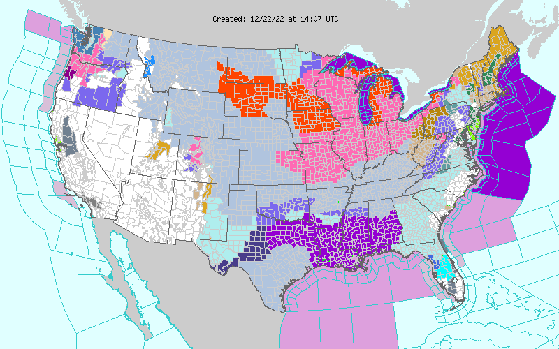
A major winter storm will form on the Arctic front affecting Canada and United States this week and bring extremely dangerous blizzard conditions to the Plains, Upper Midwest, and Great Lakes, U.S./Canada. Consider altering travel plans through the holiday weekend as road conditions are likely to become dangerous and at times, life-threatening.
- Arctic air will clash with subtropical warmth and moisture over the Mississippi Valley, sparking a weather bomb over the Great Lakes
- The storm will have a roller-coaster of weather conditions and impacts in North America due to its magnitude
- Residents across Ontario, Canada are being urged to consider altering travel plans through the holiday weekend as road conditions are likely to become dangerous and at times, life-threatening. Extensive utility outages are possible as well as road and store closures, and flight cancellations or delays.
- Widespread disruptive and potentially crippling impacts are expected across the central and eastern United States
- Record-breaking cold and life-threatening wind chills over the Great Plains are forecast to overspread the eastern half of the U.S. by Friday
Canada
A rare winter storm is fast approaching and residents across Ontario, Canada are being urged to consider altering travel plans through the holiday weekend as road conditions are likely to become dangerous and at times, life-threatening, The Weather Network (TWN) meteorologists warn.1, 2
Extensive utility outages are possible as well, alongside the chance of road and store closures, and flight cancellations or delays.
This mammoth winter storm, as TWN describes it, is set to move in at the worst time for driving — putting millions at risk of being caught on the roads during the storm through the Christmas weekend.
Heavy snow, potentially damaging winds, a flash freeze, rain, and even the risk of ice pellets are all risks with this multi-day storm.
Widespread winter storm watches and blizzard warnings have been issued, along with rainfall warnings and special weather statements also in place.
“The sheer size of this storm, the flash freeze potential and blizzard conditions with powerful winds and impressive snowfall totals are what has forecasters’ attention,” said Kelly Sonnenburg, a meteorologist at The Weather Network.
United States
A major and anomalous storm system is forecast to produce a multitude of weather hazards through early this weekend, as heavy snowfall, strong winds, and dangerously cold temperatures span from the northern Great Basin through the Plains, Upper Midwest, Great Lakes, and the northern/central Appalachians, NWS forecaster Snell noted.3
At the forefront of the impressive weather pattern is a dangerous and record-breaking cold air mass in the wake of a strong Arctic cold front diving southward across the southern Plains today, December 22, and eastward into the Ohio/Tennessee Valleys by tonight.
Behind the front, temperatures across the central High Plains have already plummeted 28 °C (50 °F) in just a few hours, with widespread subzero (°F) readings extending throughout much of the central/northern Plains and northern Rockies/Great Basin.
These temperatures combined with sustained winds of 32 to 48 km/h (20 to 30 mph) and higher wind gusts of up to 95 km/h (60 mph) will continue to lead to wind chills as low as -40 °C (-40 °F) across a large swath of the Intermountain West and northern/central Plains, with more localized areas of -45 to -56 °C (-50 to -70 °F) possible through the end of the week.
Wind chills of this magnitude can cause frostbite in less than 5 minutes if precautions are not taken, with hypothermia and death also possible from prolonged exposure to the cold.
Livestock interests will also be severely impacted and dangers could be exacerbated if power outages occur.
Widespread Wind Chill Warnings, Watches and Advisories span over 30 states from Washington to Florida.


“For areas across the Upper Midwest, Great Lakes, and Interior Northeast, a rapidly deepening low-pressure center that forms along the frontal boundary this evening and swings into the Great Lakes on Friday will have the potential to create potentially crippling conditions,” Snell said.
The snowfall totals may not seem all that impressive with this storm, but combined with very strong winds over an extended period of time will create blizzard conditions that can bring travel to a halt and strain infrastructure.
These widespread wind gusts over 65 km/h (40 mph) and potentially up over 95 km/h (60 mph) are due to a very tight pressure gradient developing between the eventual low over the Great Lakes and the strong high pressure system over the northern Plains.
The abrupt deepening of this low pressure system will also aid in the increasingly large and powerful wind field.
Heavy snowfall rates of 25 – 50 mm (1 – 2 inches) per hour, along with wind gusts of over 80 km/h (50 mph) will result in near-zero visibility and considerable blowing and drifting of snow.
This will lead to dangerous, to at times impossible, land and air travel leading up to the holiday weekend.
The timing of this cross-country winter storm could not be worse, as millions rush to finish their shopping or embark on their holiday travels, AccuWeather meteorologists said.4
During the period from December 23 to January 2, 112.7 million people in the United States are expected to travel more than 80 km (50 miles) from home, according to the American Automobile Association (AAA).
“The massive snowstorm was already affecting vast portions of the Plains and Rockies on Wednesday. As the storm strengthens into a powerful blizzard over the Midwest from Thursday to Friday, travel is likely to grind to a halt as dangerous and life-threatening conditions unfold from the storm’s high winds, snow and plunging temperatures.”
1 Blizzard, winter storm warnings issued in Ontario ahead of holiday weekend – TWN – December 22, 2022
2 Holiday havoc: Vast, 3,000-km-sized storm puts travel plans in peril – TWN – December 20, 2022
3 Major and anomalous storm system to produce widespread disruptive and potentially crippling impacts across the central and eastern U.S. – The Watchers – December 22, 2022
4 Winter storm to evolve into bomb cyclone as it produces a blizzard in Midwest – AccuWeather – December 19/22, 202


